

The quick answer
Google Maps no longer shows one worldwide name for the Great Lake between New York and the Canadian province of Ontario. Google says people using Maps in the United States now see “Lake America,” people in Canada continue to see “Lake Ontario,” and people outside both countries see both names. The company says it is following official government naming sources: the U.S. Geographic Names Information System, or GNIS, which adopted “Lake America” after an executive order, while Canada’s official names database still records “Lake Ontario.” The result is a country-specific map label, not a change to the international border and not one universally accepted name.
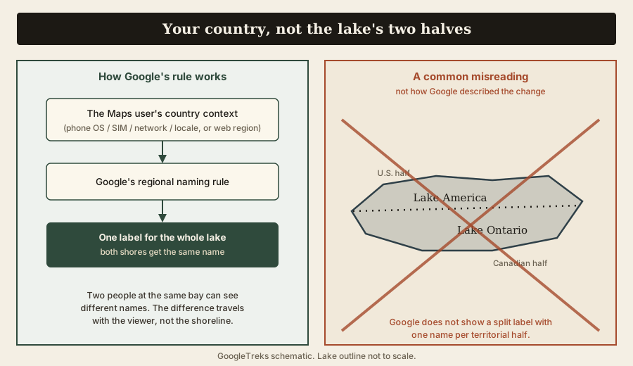
That is a display rule about the person looking at the map, not about which shoreline they are viewing. A user in Buffalo and a user in Toronto looking at the very same bay see different labels for the whole lake. Nothing about the water, the boundary, or the two countries’ rights changes.
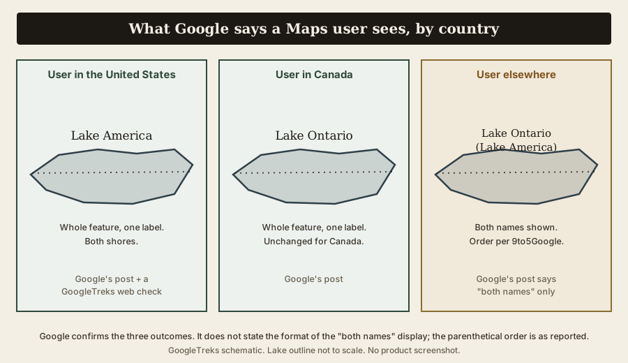
What Google Maps shows by region
Google published a short post dated August 29, 2026 titled “How the GNIS Lake Ontario/Lake America name change in the U.S. will appear in Maps.” Its central sentence:
“Since we update Google Maps to reflect name changes in official government sources, which is GNIS for the U.S., people using Maps in the U.S. will see ‘Lake America,’ those in Canada will continue to see ‘Lake Ontario,’ and those outside of the U.S. and Canada will see both names.”
Google adds that the change follows “our long-standing policy for bodies of water with names that vary from country to country,” and that the updates “are starting to roll out now.”
| User context | Google's stated label | Evidence | Limitation |
|---|---|---|---|
| In the United States | "Lake America" | Google’s August 29 announcement; U.S. web view on September 6, 2026. | Rollout is in progress, so the label may vary. |
| In Canada | "Lake Ontario" | Google's August 29 post | According to Google’s August 29 announcement. |
| Outside both countries | Both names | Google's August 29 post; 9to5Google reported the display as "Lake Ontario (Lake America)" | Google does not specify the order or punctuation; 9to5Google reports “Lake Ontario (Lake America).” |
It is the country Google associates with the person using Maps, not the half of the lake on screen.
The key distinction: your country, not the lake’s two halves
The most common misreading of this change is that Google now labels the New York side of the lake “Lake America” and the Ontario side “Lake Ontario,” as if a single map showed a border with a different name on each side. That is not what Google described.
Google’s rule keys on the Maps user’s country context. Whatever label your context produces is applied to the entire feature, north shore and south shore alike. Two people can open Maps to the identical stretch of water and see different names, because the difference travels with the viewer, not with the shoreline.
Why Google changed the U.S. label
Google says it changes a place name in Maps when the official government source for that place changes it. For features inside the United States, that source is GNIS, the federal gazetteer maintained by the U.S. Geological Survey with the U.S. Board on Geographic Names. GNIS updated this feature’s primary name to “Lake America” following Executive Order 14422 and an implementing order from the Secretary of the Interior. Google presents the Maps update as an application of its long-standing regional-naming policy after the GNIS record changed. That explains Google’s stated rationale; maintaining and applying the policy remains Google’s choice as a private map provider.
Google used the same reasoning in February 2025 for the Gulf of Mexico, which it began showing as “Gulf of America” for U.S. users after GNIS was updated. Independent coverage notes that after heavy review activity on the Gulf entry in 2025, Google limited new user reviews on that place; as of late August 2026, reporting indicates it had not applied the same limit to the lake.
How Google decides which country you are in
Google has not re-published the country-detection mechanics for this specific change. Its February 2025 explainer for the Gulf is the most detailed statement, and Google presents this change as the same policy. In that explainer:
- In the Maps app, the names you see “are based on your country location, which is determined by information from your phone’s operating system (e.g., iOS and Android), including your SIM, network, and locale.”
- On the web, the label is “based on the region you select in your Search settings or your device’s location, if you haven’t selected one.”
Several things follow, and they matter for anyone trying to “test” this:
- Country context is about the map experience Google serves you. It is not a statement about your nationality, your citizenship, or your opinion.
- It is not decided by your language alone. Locale is one signal among several.
- It is not decided by your IP address alone. Google names a bundle of signals on mobile and a selected Search region on the web.
- On the web, check your selected Search region. Changing URL parameters or browser language alone may not reproduce another country’s view.
- A commercial VPN changes your apparent IP, but Google’s described logic uses more than IP, so a VPN does not reliably flip the label.
What the U.S. government actually changed
Executive Order 14422, “Honoring the American History of the Great Lakes and Renaming Lake Ontario as Lake America,” was signed on August 27, 2026 and published in the Federal Register on September 2, 2026 (91 FR 56543, document 2026-18020). It cites the earlier Executive Order 14172 of January 20, 2025.
The order’s operative section directs the Secretary of the Interior, within 30 days and “in coordination with the Board on Geographic Names” and consistent with 43 U.S.C. 364 through 364f, to “take all appropriate actions” to rename the feature “Lake America” and to “update the Geographic Names Information System (GNIS) to reflect the renaming of the Lake and remove all references to Lake Ontario from the GNIS, consistent with applicable law.” It applies the new name to “Executive department and agency maps, contracts, and other documents and communications.” Its general-provisions section is standard boilerplate, stating that the order is “not intended to, and does not, create any right or benefit, substantive or procedural, enforceable at law or in equity.”
What the text does, in plain terms:
- It sets the name used in U.S. federal maps, records, contracts, and communications.
- It directs the federal naming body to update the federal database.
What the text does not do:
- It contains no instruction to private companies. Al Jazeera’s coverage put it directly: the order “cannot compel private companies to change their naming conventions.”
- It says nothing about Canada’s naming, New York State’s naming, the international boundary, treaties, navigation, fishing, or maritime jurisdiction. The Canada–U.S. boundary through the lake is set by treaty and is not addressed by the order.
Political reaction was immediate and is covered briefly below. It does not change what the order’s text directs.
What GNIS records right now
The GNIS record (feature ID 970427), as of September 6, 2026:
- Primary name: “Lake America.” Class: Lake. Primary state: New York.
- Citation: originator “President of the United States,” distribution date August 27, 2026, titled “Name Established by Executive Order.”
- History field: “Secretary’s Order 3453 directs the Board on Geographic Names (‘BGN’) to immediately rename Lake Ontario to Lake America and to update the Geographic Names Information System… This Order implements President Trump’s direction in Executive Order 14422.” It also notes a Mohawk variant name, “Kaniatarí:io Lake,” glossed “nice lake.”
- A site banner states the GNIS basemaps “are in the process of being updated to reflect this name change.”
- Variant names still listed include “Lake Ontario,” “Lac Ontario,” “Lago Ontario,” “Kaniatarí:io Lake,” and older forms such as “Cadaraqui.” The feature description still reads “Lake America, previously referred to as Lake Ontario.”
So the executive order instructed the Interior Department to “remove all references to Lake Ontario from the GNIS,” and as of this writing the record has changed the primary name but still carries “Lake Ontario” as a variant. That is a database-maintenance gap, not a legal contradiction, and GNIS itself says the update is ongoing.
The scope of GNIS is worth stating plainly. USGS describes it as the system that holds “the official names for geographic features” for U.S. domestic use, and is explicit about its reach: “The BGN’s authority applies only to Federal agencies and contractors. The BGN cannot require that its decisions (official names) be applied to non-Federal products.” GNIS covers the 50 states, the District of Columbia, U.S. dependent areas, and Antarctica. It is not a global naming authority and does not govern Canadian usage.
What Canada’s official database records
Canada’s Geographical Names Database, maintained by Natural Resources Canada for the Geographical Names Board of Canada, records:
- Official name: “Lake Ontario” in English and “Lac Ontario” in French.
- Status: Official.
- “Lake America” does not appear anywhere in the Canadian record.
The Geographical Names Board of Canada coordinates naming among federal, provincial, and territorial authorities; provincial bodies have jurisdiction over names within their own borders. Canada has given no indication it will adopt “Lake America.” Prime Minister Mark Carney said the name “is more than 400 years old, predating both the Confederation of Canada and the Declaration of Independence of the United States of America.” Ontario Premier Doug Ford unveiled a roadside sign near Grimsby, Ontario, close to the U.S. border, reading “Lake Ontario — Now and Always” in English and French.
The name’s deeper origin is not settled in a single form. It is commonly traced to a Wendat (Huron) or wider Iroquoian word: Carney’s office rendered it “Ontari’io,” glossed “the lake is beautiful, the lake is big,” while the GNIS record lists a Mohawk variant, “Kaniatarí:io,” glossed “nice lake.” The province of Ontario is generally said to take its name from the lake, not the other way round.
One lake, three naming systems
The clearest way to hold all of this is to keep the systems separate. Each is authoritative for its own domain and silent about the others.
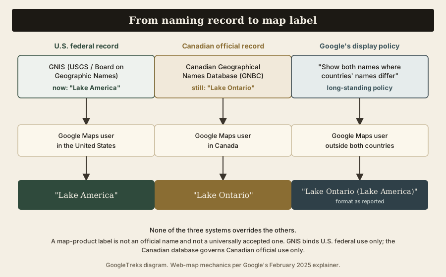
| System | Current record | What it governs | What it does not establish |
|---|---|---|---|
| U.S. GNIS (USGS / Board on Geographic Names) | "Lake America" (feature 970427); "Lake Ontario" retained as a variant | Names in U.S. federal maps, documents, and contracts | Names used by Canada, U.S. states, private companies, or other countries |
| Canadian Geographical Names Database (GNBC) | "Lake Ontario" / "Lac Ontario," status Official | Canada's official geographic nomenclature | Names used in U.S. federal records or by other countries |
| Google Maps display policy | Regional labels: U.S. "Lake America," Canada "Lake Ontario," elsewhere both | What a label looks like inside Google Maps, by user country | Any official or universally accepted name; other providers' choices |
U.S. web labels on September 6, 2026
- Google Maps (web): searching “Lake Ontario” returned the Great Lake, titled “Lake America” and described as the “Smallest Great Lake, spanning the US-Canada border.” The place card showed only “Lake America.” This was consistent across repeated fresh sessions. Searching the bare phrase “Lake America” surfaced an unrelated Florida business first, which suggests the search index still primarily keys the lake to its long-standing name.
- Apple Maps (web, maps.apple.com): the same search returned a place still titled “Lake Ontario.” This is the web map; reporting about Apple’s change concerns the iPhone app, and Apple’s rollout may be incomplete or surface-specific.
- Bing Maps (web): the feature was labelled “Lake Ontario,” with no “Lake America” text present, even with a U.S. market setting and U.S.-centered map view. These observations cover U.S. web maps only, not Canadian, third-country, or mobile views.
Google, Apple, MapQuest, and Bing
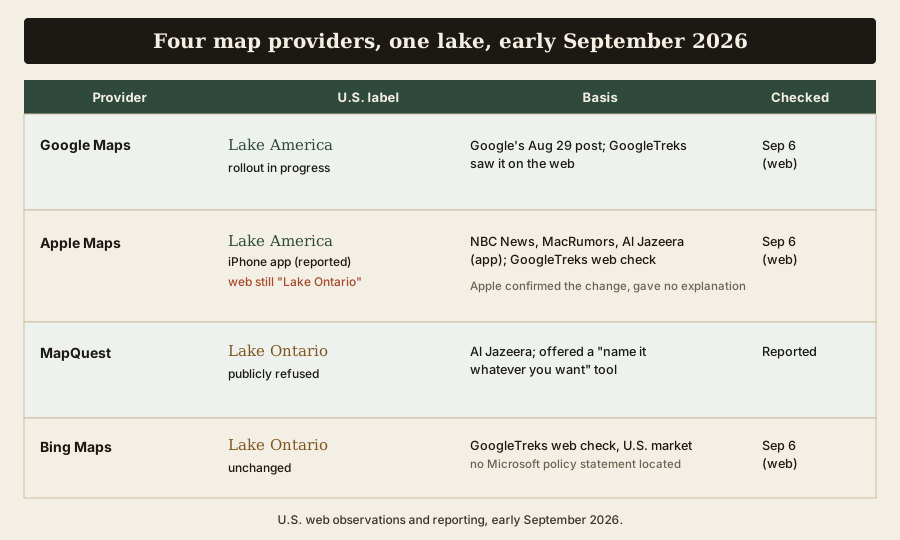
| Provider | U.S. observation or report | Canada / elsewhere | Stated policy | Last checked / uncertainty |
|---|---|---|---|---|
| Google Maps | "Lake America" (Google's post; The Maps Guide confirmed on web) | Canada "Lake Ontario," elsewhere both names (Google's post) | Follows official government sources; shows both names where countries differ | Sept 6, 2026 (web). Rollout described as in progress |
| Apple Maps | "Lake America" for U.S. users in the iPhone app, from about September 1–2 (NBC News, MacRumors, Al Jazeera). The Maps Guide saw "Lake Ontario" still on the web map | Canada "Lake Ontario," elsewhere both names (NBC News) | Apple confirmed the change, tied it to the GNIS update, and issued no explanation | Sept 6, 2026 (web). App vs web differ; rollout may be incomplete |
| MapQuest | Publicly refused to rename the lake; posted "Name it whatever you want at your leisure" and offered a custom-name tool (Al Jazeera) | Not reported | Declined to adopt the change; its app briefly became the top free app in Apple's U.S. App Store | According to Al Jazeera. |
| Bing Maps | "Lake Ontario" in our web check, with a U.S. market setting | Not separately tested | No Microsoft statement located | Sept 6, 2026 (web). |
Google announced the U.S. change, and reporting described Apple adopting it in the iPhone app. In the September 6 web checks above, Google showed “Lake America,” while Apple and Bing showed “Lake Ontario.” MapQuest’s refusal is attributed to Al Jazeera’s reporting; its map was not directly checked. A provider choosing one label or the other is a business and editorial decision. It is not evidence that the choice is legally required, and it does not settle an official name.
What a map label does — and does not — change
A label inside a map product changes what that product displays to a category of users. That is the whole of it. It does not, by itself:
- Change the U.S. federal record (that was the GNIS update, a separate step).
- Change Canada’s official record, which still says “Lake Ontario.”
- Change the international boundary, which runs through the lake by treaty.
- Oblige any person, school, newspaper, or other company to use the same word.
Conversely, the U.S. federal record changing does not compel Google, Apple, or anyone else. Google says it chose to mirror GNIS under a standing policy; MapQuest says it chose not to.
Why digital maps show different geographies
Maps have never been neutral, and digital maps make the seams visible. A modern map platform can store place-name variants and choose among them using a user’s country context. Google says it uses that approach for some geographic-name disagreements: users in each country may see that country’s official name, while users elsewhere may see both. “Lake America” and “Lake Ontario” is one example of that policy; do not assume every disputed border, territory, or body of water uses the same display rule. For a classroom, it is a sharp example of comparing sources for a mapped claim: a name in a government register, a name on a commercial map, and a name in common use.
Is “Lake America” an AI error?
No. The label is not a Gemini hallucination, not a mistaken automated edit, and not a user-submitted change that slipped through. Google’s own post attributes it to the GNIS update, which in turn implements an executive order and a Secretary’s order. Google Maps does have separate, unrelated AI features, but this label is a data change, not a generated answer. Whether you agree with the renaming or not, its origin is a documented government action, not a software bug.
The political and legislative response
The renaming is contested. Prime Minister Carney rejected it; Ontario Premier Doug Ford answered with a roadside sign; New York Governor Kathy Hochul said the state would not change the name. At the signing, President Trump linked the move to trade, telling reporters that talks with Canada had “gone badly.” On August 31, 2026, Representatives Debbie Dingell, Joe Morelle, and Tim Kennedy introduced the “Hands Off Our Great Lakes Act,” which would bar the federal government from renaming any of the five Great Lakes and would seek to nullify Executive Order 14422. As of publication the bill has been introduced only. It has not passed either chamber and is not law. The dispute is unfolding alongside a broader U.S.–Canada tariff standoff, which several outlets note as context.
What remains unsettled
- Whether Google’s U.S. rollout is complete, and whether every U.S. user now sees “Lake America.”
- The exact format Google uses for the “both names” display outside the U.S. and Canada.
- Whether Apple’s web map and other Apple surfaces will match the iPhone app, and what Apple shows outside the U.S. and Canada in practice.
- Whether Bing or MapQuest change course, and whether either issues a policy statement.
- Whether GNIS finishes removing “Lake Ontario” as a variant, as the order directs, or leaves it.
- Whether the “Hands Off Our Great Lakes Act” or any other measure advances.
- Whether Canada or Ontario issues any formal or legal step beyond the Prime Minister’s remarks and the Ontario Premier’s sign.
What to watch next
Concrete signals that would change this story: a Google statement that the rollout is complete or a change to the “both names” format; an Apple explanation or a web-map update; a Microsoft or MapQuest policy statement; a further GNIS edit; any committee action or floor vote on the Great Lakes bill; a formal Government of Canada or Government of Ontario response; or a correction from any of the sources above.
Timeline
- January 20, 2025 — Executive Order 14172 establishes the naming policy that Executive Order 14422 later cites.
- August 27, 2026 — Executive Order 14422 signed; the Secretary of the Interior issues an implementing order; the GNIS record’s primary name becomes “Lake America.”
- August 27, 2026 — Prime Minister Carney says Canada will keep using “Lake Ontario.”
- August 29, 2026 — Ontario Premier Doug Ford unveils a “Lake Ontario — Now and Always” sign near Grimsby; Google publishes its post on how the change appears in Maps.
- August 29–30, 2026 — the “Lake America” label is observed for U.S. users in Google Maps.
- August 31, 2026 — the “Hands Off Our Great Lakes Act” is introduced in the U.S. House.
- September 1–2, 2026 — Apple Maps begins showing “Lake America” for U.S. users in the iPhone app; MapQuest publicly refuses and its app tops the U.S. App Store.
- September 2, 2026 — Executive Order 14422 published in the Federal Register (91 FR 56543).
- September 6, 2026 — U.S. web views show “Lake America” in Google Maps and “Lake Ontario” in Apple Maps and Bing Maps; GNIS still lists “Lake Ontario” as a variant.
The Maps Guide is an independent classroom-mapping resource. It is not a Google product and is not affiliated with Google LLC.
The Maps Guide background reading: research and cite a mapping project for a classroom method of comparing place-name sources.


