
My Maps is a separate editor, not another name for Google Maps. A saved Maps list, a custom My Map and an Earth project are different items, even when they contain the same places.
| Your decision | Google Maps | Google My Maps | Google Earth |
|---|---|---|---|
| Main result | A place, journey or saved collection | A reusable custom map with layers | A terrain view or place-based story |
| What you organize | Saved places and shareable lists | Points, lines, shapes and imported rows | Project features, imported data layers or local KML |
| Navigation | Turn-by-turn directions | Planning lines and directions layers, not navigation | Paths and globe exploration, not navigation |
| Where to work | Computer browser or phone app | Computer for creation and editing; mobile viewing | Web, mobile or Earth Pro, depending on the task |
| What you share | A place, route or list | A map with viewing or editing access | A shared Drive project or a separate file copy |
For an example of the three tools working together, follow a fictional family weekend from trip planning to a class map project.
Plan a day out without building more than you need
Suppose you’re visiting a river town. You’ll arrive at the station and want to see a museum, a riverside park and a hilltop viewpoint.
Start in Maps. Enter the station and museum in Directions, choose your travel mode and inspect the proposed route. If your only question is how to get there, you can stop here. On a computer, choose a route and use Share to copy its link. Google’s directions instructions also cover printing and sending directions to your own device; the Send to phone option does not support multiple destinations.
If the park and viewpoint become part of the same outing, decide their order before relying on the route. Maps calculating a route is not the same as optimizing your whole day’s stop sequence. The multiple-stops guide explains that distinction. For a driving trip, check any toll, highway or ferry preferences separately.
Use Street View to inspect the surroundings, but check its capture date: imagery is not live. If Street View will not open for a road, check its coverage first. If reception may be poor, prepare and check a Google Maps offline download for eligible driving navigation. A printed route can provide a separate reference.
If you only want to keep a shortlist of places, a shareable Maps list may be enough. The distinction between labels, lists and Starred places matters more than adding another app.
Keep a custom map when the notes and alternatives matter
Now suppose someone else will reuse your river-town plan next month. They need to see the intended stops, alternatives and reasons for choosing them. That is a useful My Maps job. Our custom-map walkthrough follows one map from its first marker to a shared, saved copy.
- On a computer, sign in at My Maps and create a map named River-town visit.
- Name the first layer Planned stops. Use Add layer to create Alternatives, so possible substitutions do not look like part of the agreed itinerary.
- Add the places and a short note to each. For example, a museum note could say to confirm opening hours before fixing the day’s order. Inspect the marker’s location rather than trusting a familiar-looking place name.
- Give the people following the plan viewing access. Give editing access only to people who should change it, then ask a recipient to open the link with the intended account.
Google’s Drive guidance for My Maps covers those permissions. My Maps do not consume Drive storage quota, but they are not available offline. On a phone, opening the map from Drive can take you to a browser view; create and edit on a computer rather than following tutorials for the retired dedicated Android app.
For a spreadsheet-backed version, prepare headings such as Name, Address, Category and Notes. Add a layer, choose Import and select the file. After import, inspect the locations and style by Category if that helps distinguish the stops. The spreadsheet import guide covers field choices and later updates; if the import fails or drops information, use the import troubleshooting guide.
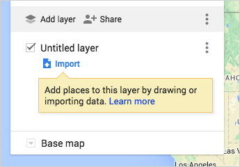
Importing a Sheet does not create automatic synchronization. Reimport and merge are deliberate actions. Keep the original data before updating: the Update matching items option removes existing features that do not match the new file.
For larger maps, check the limits before preparing the whole dataset. Google’s drawing limits allow 10,000 places, lines or shapes per map, 2,000 per layer, 50,000 total points within lines and shapes, and 20,000 data-table cells. A map can have up to 10 layers.
The import formats and limits include CSV, TSV, KML, KMZ, GPX, XLSX, Google Sheets and photos. Keep tabular imports to 2,000 rows or fewer. Uncompressed KML/KMZ content has a 5 MB limit; other supported files can be up to 40 MB. Location fields can use coordinates, addresses, place names or supported WKT geometry.
A directions layer can help organize the plan, but it does not turn My Maps into a navigation app. Return to Maps for travel guidance. My Maps can also merge matching table records; that is different from a spatial join. For buffers, spatial joins or deliberate projection control, choose a dedicated GIS workflow.
Use Earth when the landscape changes the question
The hilltop viewpoint gives the example a different purpose: explaining how the town sits beside the river and surrounding slopes. Open Google Earth, create a Drive project and add the relevant places. Choose views that make the relationship visible, then add short descriptions explaining what each view shows. Keep route and access decisions in Maps rather than treating a drawn Earth path as a safe walking route.
For change over time, use historical imagery to inspect the dates available at that location, or Timelapse for animated change. Maps has Street View dates, but not a satellite-history slider. Neither a recent-looking image nor a selected year guarantees complete coverage of the place you need. If the imagery looks blurry or the globe will not load, work through the Earth loading checks.
If the question concerns length, area or slope, first choose the quantity in the Maps and Earth measurement guide. Web Earth and Earth Pro both have elevation-profile workflows, with different controls. If your source supplies a numeric location, the Earth coordinates guide explains the order and formats.
Before importing anything, distinguish Earth’s three data types:
- Map features are individually editable placemarks, lines and polygons in a Drive project. Simple KML/KMZ imports suit roughly 10,000 features or 250,000 vertices; oversized imports can automatically become data layers instead.
- Experimental data layers display larger datasets inside a Drive project. You can style the layer, but not directly edit its source features. They consume Earth storage quota. CSV and Google Sheets imports are also Experimental data-layer workflows, not substitutes for My Maps’ editable table workflow.
- Local KML files remain outside Drive projects. Web files save to your computer; mobile files use local app storage. Save or download your changes explicitly. Autosave is supported only in Chromium-based computer browsers.
If you still have legacy KML stored inside the browser, download it or add it to a map project by January 14, 2027. That deadline concerns the older browser storage, not every KML file.
The Earth version comparison helps with the next choice. Earth Pro is the free desktop app, not the paid Professional cloud plan. Even familiar features differ: the flight simulator guide separates Experimental computer-web flight from Pro’s classic simulator; the web simulator is unavailable on mobile.
Share the map you mean to share
A route link, a custom map and an exported file give recipients different things.
On a computer, Google Maps shows your five most recent My Maps under Saved → Maps. Choosing Open in My Maps takes you back to the editor, as Google’s viewing instructions explain. Viewing the custom map there does not make its drawn lines navigable.
For a website embed, My Maps requires a public map. A public map can be found by other people, so remove private addresses and identifying personal details before changing access. Google’s sharing and download instructions also distinguish a whole-map KML/KMZ export from an individual-layer CSV export.
To view the river-town map on Earth’s globe, use Menu → View in Earth in My Maps. This is a view-only connection: changes made in My Maps appear after refreshing Earth, and the map does not work in Earth Present mode. On the web, Copy to Map Project creates a separate editable Earth project and leaves the My Map intact.
An exported KML/KMZ is another separate copy, not that refreshable connection. The My Maps export guide explains which output to choose. Once you have the file, the Earth import guide helps you choose editable features, a data layer or local storage. Keep the original map and source table, then inspect the destination’s markers, descriptions, styles and important media before handing it over.
Adapt the same plan for a class
For a class visit, start with a teacher-owned map and viewing access unless a named group needs to edit. The teacher guide covers preparation and delivery; the student-sharing instructions cover permissions and hand-in arrangements.
Check the actual school account before assigning work. Under Google’s school-account restrictions, accounts designated under 18 cannot use paid Maps/Earth features, publish comments or reviews, participate in Local Guides, enable Location History, access Timeline or share their live location. Ask the administrator to confirm service access and that the required parent or guardian consent is in place before under-18 students use Additional Services with their school accounts. Do not bypass restrictions with personal accounts.
Keep home addresses, students’ full names and identifiable photos of minors out of a public map. Repeat the legend in a simple table, use labels as well as color, caption media and provide still views or a print alternative to a moving globe. For a research assignment, student map projects connects the geographic question to sources, captions and a finished presentation.


