
Use the My Maps editor on a computer. If you need the normal upload procedure rather than troubleshooting, start with our CSV, Excel, and Google Sheets import guide.
“Anonymous uploads are not allowed”
Work through these checks before changing the spreadsheet:
- Account picture: confirm that My Maps is using the Google account that owns or can edit this map.3
- Share: check that the intended account is the owner or has Can edit access. Can view, including Can comment on a map, is not edit access.1
- Import window: if the browser blocks Drive, follow Google’s import troubleshooting guidance to allow
https://mymaps.google.com/to open Drive. Keep the change specific to that site and the observed block.2 - Retry on a copy: in a new map, add a layer and choose Import beneath it. Test two to five non-personal rows before retrying the full dataset.3

If the import picker offers Drive, compare a computer upload with the same small file in that account’s Drive.
Keep any browser change specific to the observed block. Do not make the map public, sign students into personal accounts, or clear all Google account data as the first response.
Already signed in? Being signed in is only the first check: the account shown in My Maps must also have Can edit access to this map.1 The message alone does not show which check failed, so it does not mean your map must be public or that your spreadsheet is corrupt. If both the full file and the tiny sample fail, keep the file unchanged and send feedback with the exact wording and the last step you reached.
Different wording? If your message says “anonymous files” or appears in another language, note the exact text and where it appeared, then use the same checks. Our error messages in 8 languages list shows the wording we have found in each language. A message about location columns comes from a different stage: see the location-column section.
Google Maps or Google My Maps: which one shows the error?
Use Google My Maps, the custom-map editor—not the ordinary Google Maps search or directions screen—for the layer-import workflow. Open My Maps on a computer, sign in, and use Add layer → Import.3 For a CSV, Excel file or Google Sheet, use the spreadsheet import steps once access is working.
Identify where the import fails
One symptom is not a diagnosis. Choose the first reversible check that fits what you actually see.
| What happens | Check first |
|---|---|
| Import is missing | My Maps on a computer, the current account, and edit access |
| “Anonymous uploads are not allowed” | Account and upload access before changing the spreadsheet |
| File is rejected immediately | Actual file format, titled first row, row count, and size |
| Location-column error | Only the columns that contain a coherent location method |
| Only some rows appear, or pins are wrong | Failed versus successful rows in the layer’s data table |
| Import disappears or every file fails | The same tiny sample in a new blank map |
| Reimport removes features | Stop further updates; preserve what remains and check the chosen operation |
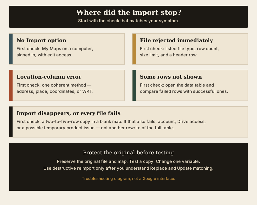
Protect the original before troubleshooting
Work from a duplicate of the spreadsheet. Keep a separate copy of any map you value, and perform experiments in a temporary map rather than repeatedly overwriting its layers.
My Maps can export a whole map to KML/KMZ and an individual layer to CSV. Save and inspect a copy before a risky retry; an export is not a promise of a complete undo.4
Our export-and-verify guide explains what to save and compare. Preserve the original source file too: exporting the current map cannot recover content that has already disappeared.
Before each test, record the file, map, account, and single thing you changed. Stop when a change produces a different result. Otherwise, a successful retry after five simultaneous changes tells you very little about which one helped.
Import option missing or unavailable
On a computer, sign in to My Maps, open or create a map, choose Add layer, and select Import beneath that layer. If you can view but cannot edit the map, ask its owner for edit access.3
The regular Google Maps search screen is a different interface. Current mobile Help also directs this My Maps workflow to a computer; use the computer editor for these checks rather than trying to reproduce its controls in the Maps phone app.
Confirm that the signed-in account is the map owner or has Can edit access. Can view is insufficient; for My Maps, Can comment works like Can view. See sharing a My Map if you need to resolve access with its owner.
A Workspace administrator can turn My Maps on or off for users. If a school or work account cannot use it, ask the administrator to check access.5
For a class dataset, follow the school’s account and sharing rules. A blocked service is a reason to contact the administrator, not to move student data into a personal account.
File is rejected before location columns
Google lists CSV, TSV, KML, KMZ, GPX, XLSX, Google Sheets, and photos from Drive or Google Photos as supported inputs. The list names XLSX, not the older XLS format.6
For tabular files, the first row should contain column titles. Location data can be latitude/longitude, addresses, place names, or WKT geometry. The location-column choice determines where features go; the later marker-title choice determines what they are called.7
Open the duplicate in a spreadsheet and inspect its actual contents. A downloaded HTML error page or JSON response does not become a table merely because its filename ends in .csv. Check the complete content rather than treating one opening character as proof of an invalid file. Renaming an XLS file to XLSX likewise does not convert it.
Check for a clear header row, stray introductory text, empty location cells, and values that split into the wrong columns. In a plain-text CSV, a comma inside an address is different from a comma separating fields.
CSV fields may be enclosed in double quotes. Fields containing commas, line breaks, or double quotes need appropriate quoting; removing every comma or quote can damage valid data.8
Use the spreadsheet’s export function to produce a fresh copy, then inspect the exported rows. Re-exporting may not fix an encoding problem; do not diagnose the cause from a BOM or quoted coordinates alone.
Check file size and map limits
Google says not to import files with more than 2,000 rows. Unzipped KML/KMZ files can be up to 5 MB; other files can be up to 40 MB. Photos have a separate limit of 100 per import.9
A map can contain up to 10 layers and 10,000 lines, shapes, or places in total. It also has limits of 50,000 total points within lines and shapes and 20,000 data-table cells; one layer can contain 2,000 lines, shapes, or places.10
| What to inspect | Why a small file may still fail |
|---|---|
| Unzipped KML/KMZ size | The compressed KMZ download size alone does not establish its unzipped size. |
| Features already in the layer or map | A new file does not reset the existing layer or whole-map totals. |
| Points within lines and shapes | A few dense geometries can contain many individual points. |
| Data-table cells | Row count alone does not describe how wide the data table is. |
Splitting a large dataset can help isolate a problem or keep individual imports small. It does not multiply the whole-map allowance: ten available layers do not mean ten layers of 2,000 features will fit in one map. Check the intended final map as well as each file.
“We’re having trouble finding those locations”
If the message also asks “Did you pick the correct location columns?”, revisit that selection. Choose fields that describe a location, not every field in the spreadsheet. Descriptive notes, an internal ID, and a marker’s name may be useful without being suitable location inputs.7
For an illustrative table with Place, Address, and Notes, choose Address to position the features, then Place for their titles. A title such as “Library visit” is not a substitute for the address of the intended library.
Keep the small test simple: use one address field, a latitude/longitude pair, place names, or WKT. If the original mixes several methods, separate a few comparable rows before testing. Do not assume that selecting extra columns will repair incomplete locations.
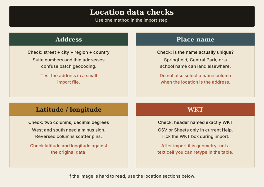
Some rows couldn’t be shown
Open the layer menu and choose Open data table. Compare a failed row with a successful row using the same location method. Look for:
- A blank location, a heading repeated among data rows, or a note masquerading as a place.
- An address missing its town, region, postal code, or country where that context is needed.
- A generic place name that could describe several places.
- Coordinates with swapped columns, a lost minus sign, or punctuation changed during export.
Keep a source-row ID so you can compare records rather than counting visible pins alone. Check the imported table and several known locations before treating the upload as complete. An import that finishes is not proof that every intended feature is present or correctly located.
Pins appear in the wrong place
For addresses and names, add enough context to distinguish the intended place, then retry only the affected sample. For coordinates, compare against the original source and check which column you selected for latitude and longitude. Do not “correct” a negative value merely because it looks unusual.
If you need help recognizing coordinate notation or checking a point, use our latitude and longitude guide. Keep any conversion separate from the upload test so you can see which change affected the result.
Use a small control file
Use public places and no student addresses or private locations. Use the address sample CSV or coordinate sample CSV to compare file structure.
Create a two-to-five-row copy of your own file too, preserving its headers. Compare that with the structural sample in a new disposable map.
| Observed result | Useful next step |
|---|---|
| Sample imports; your small copy fails | Compare format, headers, chosen location fields, and values. |
| Your small copy imports; the full file fails | Check limits and isolate additional rows or columns. |
| The same file works in a blank map only | Inspect the original map’s access, existing features, and totals. |
| Both samples fail in a blank map | Record account, access, browser, and upload behavior; repeated data rewrites are unlikely to be the next useful test. |
If the small copy works, test larger subsets in temporary layers, retaining the header each time. Narrow a failing subset further. If removing a descriptive column changes the result, inspect that column rather than deleting it from the original dataset. Add it back separately to check the comparison.
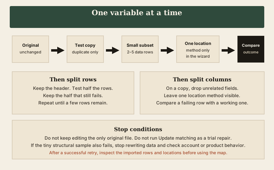
Import starts, disappears, or does nothing
Repeat the small-copy test in a fresh blank map and note whether you reached the location-column step. If the file used to work, compare the last working copy with the current one: additional rows, changed headers, wider tables, new geometry, or a different export format are useful differences to examine.
A failure across several small files may involve account access, the browser, an upload step, or temporary product behavior. Pause repeated retries, retain the observations, and send useful feedback if the problem continues.
If you compare another approved browser or profile, use the same account and sample. Avoid combining a browser change with a rewritten file and different map, because the outcome will be harder to interpret.
Reimport or update caused a problem
Stop before another reimport. Preserve the original input and export what remains of the layer. Check exactly which operation was selected.
Update matching items is not an add-only operation: Google says it deletes original features that do not match the new file, preserves matching features including photos or custom styles, and adds new features from the file.11
Replace all items deletes the existing layer data and replaces it with features from the selected file. Add more items adds data; Merge matching items combines datasets using a matching column. Google documents these reimport options for Google Sheets and CSV.12
For example, suppose the original layer contains records A, B, and C, and the replacement file contains A, C, and D. With Update matching items, matching on those IDs preserves A and C, adds D, and deletes B because B has no match.
Before choosing an operation, write down the intended result:
- Replace the layer: use Replace all only when removal of the existing layer data is intended.
- Update a complete current set: check that the matching file includes every original feature you intend to keep.
- Append new records: consider Add more items; inspect the result for unwanted repeated records.
- Join additional information: use Merge matching items with a checked matching column.
Test on a disposable copy first. Keep a stable, unambiguous match field rather than relying on a changing place name. Do not assume that editing the source Sheet has already updated the map: use the documented reimport workflow and verify the resulting layer.
Do not assume an unwanted reimport has a feature-level undo. Rebuilding may require an earlier source or export. A later export cannot restore items that are already gone.
WKT imports but cannot be edited as text
For WKT imports, use CSV or Google Sheets and name the geometry column WKT. Once imported, WKT becomes geometry rather than text: edit it with the standard geometry tools, not as an address-like value in the table editor.13
This distinction matters after a successful import. Being unable to rewrite the WKT cell like an address does not by itself mean the upload failed. Keep the source geometry file unchanged if you will need to regenerate or compare the shapes later.
KML, KMZ, or GPX failed
For KML/KMZ, check the unzipped size and expected content as well as the number of features. Do not assume that accepting a file type means every feature inside it is supported.
For Earth rather than My Maps, see how to import KML into Google Earth.
Google warns that KML may not import HTML or JavaScript information balloons, tours, time-based elements, image or screen overlays, MultiGeometries, 3D models, and folders completely.14
Compare the imported map with the original before sharing or deleting anything. If advanced Earth content matters, keep the original and use the appropriate Earth workflow rather than treating a simpler My Maps result as a faithful copy. For GPX, keep the distinction between importing map content and creating a navigation route; our GPX-to-Google Maps guide covers that separate task.
Send feedback or report the problem
To report a continuing problem, open or create a map on a computer, choose Help at the bottom, then Send feedback.15
Include the exact error wording, date and time with timezone, file type and approximate size, row count, browser, account type, and whether a tiny sample failed in a blank map. State the last step that appeared and the one-variable comparisons you tried.
Share a minimal public-data example when appropriate. Remove student information, private locations, email addresses, and access details from screenshots or files. A concise reproduction is more useful than a full private dataset or an unsupported claim that the service is down.
Sources and update note
Checked 31 October 2026 against Google’s current import, map-limit, layer, access, export, and feedback documentation. RFC 4180 describes general CSV structure, not My Maps-specific parsing.
Our guides used
- The Maps Guide: How to Import CSV, Excel, or Google Sheets into Google My Maps.
- The Maps Guide: How to Export Google My Maps to KML or KMZ—and a Layer to CSV.
- The Maps Guide: How to Share a Google My Map With Students.
Footnotes
-
Google Drive Help: Manage maps and their viewing or editing permissions. ↩ ↩2 ↩3
-
Google My Maps Help: Drive-access troubleshooting. ↩ ↩2
-
Google My Maps Help: Import map features from a file and Create or open a map. Android and iPhone/iPad Help describe the current computer workflow. ↩ ↩2 ↩3 ↩4
-
Google My Maps Help: Download map and layer information. ↩
-
Google Workspace Admin Help: Turn My Maps on or off for users. ↩
-
Google My Maps Help: Supported import inputs. ↩
-
Google My Maps Help: Import data requirements; Google Earth Outreach: location-column and marker-title steps. ↩ ↩2
-
RFC Editor: RFC 4180, section 2, describing common CSV quoting conventions. ↩
-
Google My Maps Help: Import file, row, and photo limits. ↩
-
Google My Maps Help: Map, layer, point, and cell limits and up to 10 layers. ↩
-
Google My Maps Help: Update matching items and deletion behavior. ↩
-
Google My Maps Help: Replace, add, and merge options. ↩
-
Google My Maps Help: WKT headers and geometry editing. ↩
-
Google My Maps Help: KML import limitations. ↩
-
Google My Maps Help: Report a problem and send feedback. ↩


