
To export a finished My Map or move it into Earth, use the My Maps export and Earth handoff guide. To open an authorized existing KML/KMZ in Earth, use the Earth file-import guide. For classroom planning, see Google Maps for teachers; to choose a product, see the Maps, My Maps, and Earth comparison.
For the wider choice between spreadsheets, GPS tracks and geographic files, use the map-file formats guide before converting your data.
Before you import
- Use My Maps in a browser on a computer. Current Help for Android and iPhone states that My Maps is not available on those devices.
- Sign in.
- Put titles in the first row.
- Decide one location method: a full address, a unique place name, a latitude/longitude pair, or WKT.
- Keep the file at or under 2,000 rows. Other files can be up to 40 MB; unzipped KML/KMZ files have a separate 5 MB cap.
- Strip student homes, last names, and private notes before the file ever touches a map.
- Decide which field should title the markers. That is editorial: a readable Place field beats an ID or an address.
Download a working sample
These original Maps Guide templates use a header row, one location method, and one row per public institution; they are not Google-approved templates.
Replace the rows with your own public data. Keep the header row. Do not put student home addresses in the file.
Address sample
my-maps-address-sample.csv
Seven public places located by one Address column. CSV, UTF-8, about 1.5 KB, 7 data rows.
Coordinate sample
my-maps-coordinate-sample.csv
Seven public places located by Latitude and Longitude. CSV, UTF-8, about 1.2 KB, 7 data rows.
Use My Maps, not ordinary Google Maps
Ordinary Google Maps is for search, directions, and Street View. It does not document a spreadsheet import. Saved lists in Maps are not a substitute for a My Maps layer.
If the same places must become one navigated trip rather than a reusable data layer, use the Google Maps multiple-stops guide and enter only the supported itinerary. My Maps import organizes many places; it does not automatically choose their visit order.
Google My Maps is the product with Import on a layer.
Choose CSV, XLSX, or Google Sheets
Current Help lists CSV, TSV, XLSX, and Google Sheet among the spreadsheet-like types. It does not list legacy .xls.
| Source | When it is useful | Direct import | Later update | Limitation |
|---|---|---|---|---|
| CSV | A clean, portable table you can email or archive | Yes | Reimport and merge is documented for CSVs | Values only. Formulas and cell colors are not map data. |
| TSV | The same job as CSV when the delimiter is a tab | Yes | Help names Sheets and CSVs for reimport, not TSV | Still needs a header row and a location field. |
| XLSX | The workbook is already Excel and you do not want an extra export | Yes, as .xlsx | Reimport is documented for Sheets and CSVs, not XLSX | Legacy .xls is not on the current file-type list. For a simpler import, use one sheet and avoid merged cells. |
| Google Sheet | The class already lives in Drive | Yes | Reimport and merge is documented for Sheets | The map does not stay live-synced. Reimport is a manual step. |
CSV is the most portable archive. A Google Sheet is the least friction if the table will grow. XLSX can be imported, but if you expect to replace or match rows later, keep a CSV or Sheet as the durable copy.
Prepare the header row
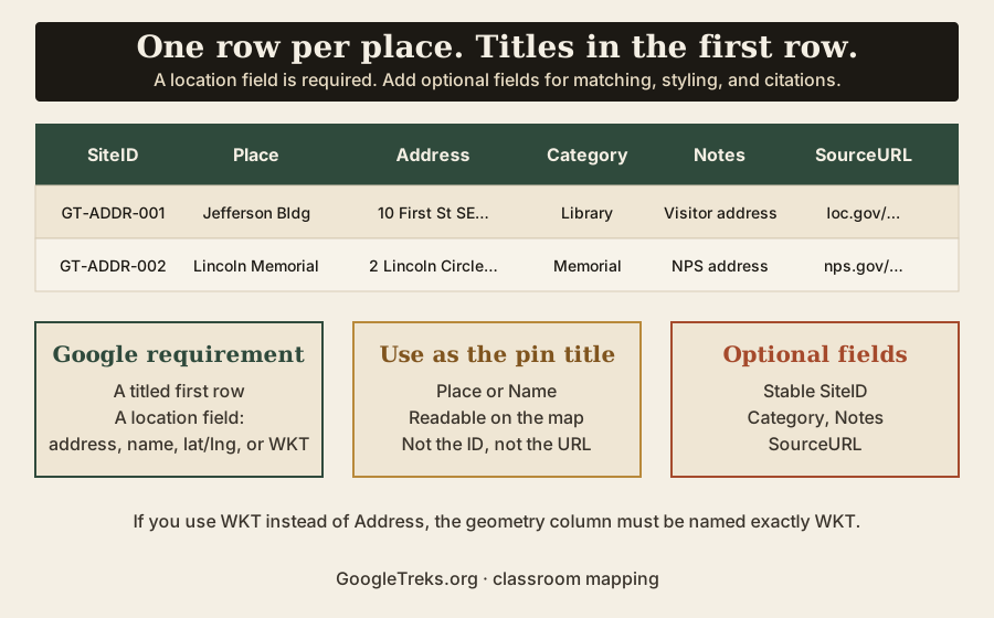
Google requirement: unless the file is a photo, the first row should have titles, and one column must locate the row.
Recommended fields and formatting:
- One row per place or feature.
- Human-readable header names.
- A stable unique
SiteIDif you will Update matching or Merge later. - A
Categoryfield if you will style by a column. - A
SourceURLif the map is student research.
The only exact header name current Help requires is WKT, and only when you use WKT.
Choose how My Maps will locate each row
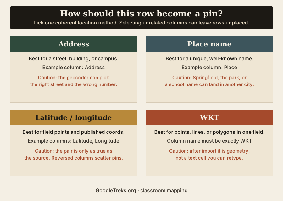
Help currently accepts four location methods. Use one per import.
| Method | Use it when | Example columns | Precision concern | Official limit |
|---|---|---|---|---|
| Address | You have a street, building, or campus address | Address | The geocoder can pick the right street and the wrong number | Help lists “Addresses”; it does not require the header to be named Address |
| Place name | The name is unique and well known | Place | Common names land in the wrong city | Help lists “Place names” |
| Latitude and longitude | You have published decimal coordinates | Latitude, Longitude | Check the source coordinates and confirm that the latitude and longitude columns are in the correct order. | Help lists “Latitude-longitude information” |
| WKT | A single geometry field holds points, lines, or polygons | WKT | A misspelled header is not WKT | CSV or Sheets; column named “WKT” only |
Address-based sample
The downloadable address file uses one Address column. Select that column during import; its header does not have to be named Address.
SiteID,Place,Address,Category,Notes,SourceURL
GT-ADDR-001,Library of Congress Thomas Jefferson Building,"10 First Street SE, Washington, DC 20540",Library,Official visitor address for the Jefferson Building.,https://www.loc.gov/visit/directions/
GT-ADDR-002,Lincoln Memorial,"2 Lincoln Memorial Circle NW, Washington, DC 20002",Memorial,NPS physical address on the Directions page.,https://www.nps.gov/linc/planyourvisit/directions.htm
GT-ADDR-003,Independence Hall,"520 Chestnut Street, Philadelphia, PA 19106",Historic site,NPS lists this as the GPS address for Independence Hall.,https://www.nps.gov/inde/planyourvisit/independencehall.htm
Excerpt from the address sample. The downloadable file has seven public rows.
Every address is a public institution or landmark. None is a residence. None is student data.
Coordinate-based sample
The coordinate file uses decimal degrees. West longitudes are negative numbers. They are numeric data, not formulas. For a single pair, the Google Earth coordinates guide explains latitude-first search, conversion, and why KML uses the opposite order; return here when the job is importing many rows.
SiteID,Place,Latitude,Longitude,Category,Notes,SourceURL
GT-COORD-001,Lincoln Memorial,38.889269,-77.050176,Memorial,Library of Congress HABS DC-3 latitude/longitude.,https://www.loc.gov/pictures/item/dc0472/
GT-COORD-002,Washington Monument,38.889428,-77.035208,Memorial,Library of Congress HAER DC-5 latitude/longitude.,https://www.loc.gov/pictures/item/dc0968/
GT-COORD-003,Gateway Arch,38.62452,-90.18471,Memorial,Library of Congress HALS MO-6 latitude/longitude.,https://www.loc.gov/pictures/item/mo2064/
Excerpt from the coordinate sample. The downloadable file has seven public rows. Coordinates come from Library of Congress HABS/HAER records.
Select both Latitude and Longitude as the location columns, then check the imported positions.
Step-by-step import
If a control is missing or renamed, check My Maps import Help for the current labels.
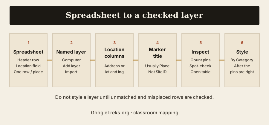
- On a computer, sign in to My Maps.
- Open a map or click Create a new map.
- In the map legend, click Add layer.
- Name the layer for the dataset, not “Untitled layer.”
- Under the new layer, click Import.
- Upload the CSV or XLSX, or choose the Google Sheet, then click Select.
- Choose the column or columns that locate each row. If you use WKT, Help says to click the checkbox for WKT and choose that column.
- Choose the column that should title each marker. Pick Place, not SiteID.
- Finish the import.
- Count the pins against the spreadsheet row count. Open the data table. Spot-check at least three places you already know.
If Chrome blocks Drive, Help says to allow https://mymaps.google.com/ to open Drive. That is a browser permission, not a My Maps setting.
Choose the marker title
SiteID is for matching on a later reimport. Place is for humans reading the map.
Use Place (or Name) as the marker title. Keep SiteID in the table. They do different jobs. Place and SiteID are suggested column names, not required ones.
Check the import before styling
- Compare pin count to row count.
- Open the data table and look for blank location fields.
- Inspect pins that landed in the ocean, in the wrong city, or stacked on 0,0.
- For coordinates, confirm latitude is the north-south column.
- For addresses, spot-check a known building, not only the first row.
- For place names, search the same name in ordinary Maps and see whether My Maps agreed.
- If you will Update matching later, confirm SiteID values are unique.
Style by a data column
After the pins are in the right places, open the layer’s Style control. Current layer Help lists:
- Uniform style
- Sequence of numbers
- Individual styles
- Style by data column (ranges or categories)
The sample files include Category so you can style by that column: Library, Memorial, Historic site, and so on. Do not encode meaning by color alone. Repeat the category in the table and in the map description. Use map layers is the official page for those style choices.
Update or reimport data later
The map does not stay linked to the Sheet. Current Help documents a manual Reimport and merge path for Google Sheets and CSVs. It does not document the same menu for XLSX.
| Operation | What it does | What may be removed or retained | Best use |
|---|---|---|---|
| Replace all items | Deletes existing map data in the layer and loads the file | Everything in the layer is replaced. If you styled by a data column, Help says those style rules can copy to the replacement data. | A full weekly refresh of the same table |
| Update matching items | Matches a column in the layer to a column in the file | Matches keep photos and custom styles. New rows are added. Unmatched original features are deleted. | A living list with a stable SiteID, after you accept the deletions |
| Add more items | Appends the file to the existing layer | Existing items stay. You can create duplicates if the same place is in both files. | A genuinely new batch, not a corrected copy of the old file |
| Merge matching items | Joins a second file onto the layer using a shared column | Rows match on the columns you pick, such as a state code in both files | Adding attributes, not replacing locations |
Update matching is destructive for leftovers. Help is explicit: original features that do not match the new file are deleted. Export the layer to CSV before you use it.
A stable SiteID makes matching possible. It is not mandatory. If you match on Place instead, a repeated place name may not identify a row uniquely.
Current import limits
- Do not import more than 2,000 rows.
- A layer can hold 2,000 lines, shapes, or places.
- A map can have 10 layers.
- A map can have up to 10,000 lines, shapes, or places.
- Other files: up to 40 MB. Unzipped KML/KMZ: up to 5 MB.
- Photos: up to 100 at a time.
There is no school-license switch that raises those caps.
Privacy and classroom data
Treat the spreadsheet as the privacy boundary. Once a row is on a map, sharing the map shares the table.
- No student home addresses.
- No precise personal locations.
- No last names in a file you might share or embed.
- No identifiable private notes in the Notes column.
- Use public places or intentionally generalized data.
- Review sharing after the import, using the My Maps sharing guide.
- Do not use a personal Gmail account to bypass school policy.
This is classroom privacy guidance, not legal advice.
Accessibility
Keep the source table. The interactive map is not a complete alternative.
- Publish the same places as a table or a printed list.
- Use text labels as well as color when you style by Category.
- Write Notes and captions that still make sense without the basemap.
- Do not make pin color the only way to tell Library from Memorial.
The mapping research guide covers source tables, shared notes and source checks around the map.
Quick troubleshooting
For “Anonymous uploads are not allowed” in My Maps, start with account and upload access. The same guide covers rejected files, missing locations and reimport changes; use the first checks below to choose your next step.
| Symptom | Likely cause | First check | Official source |
|---|---|---|---|
| File type rejected | Legacy .xls, a wrong delimiter, or a non-listed type | Save as CSV UTF-8 or .xlsx. Confirm the type is on the Help list. | 3024836 file-type list |
| Location columns not recognized | No header row, or the wrong columns selected | Titles in row 1. Select Address, or both Latitude and Longitude, or WKT. | 3024836 prepare-your-info |
| Pins in the wrong places | Ambiguous names, thin addresses, reversed coordinates | Spot-check three known rows. Confirm lat/lng order. | My Maps import Help: check location accuracy after import. |
| Missing rows | Blank location values, or the file is over 2,000 rows | Count rows. Split the file. Inspect blanks in the table. | 2,000-row advice; 2,000 features per layer |
| WKT not recognized | The column is not named exactly WKT | Rename the header to WKT. Check the WKT box during import. | “labeled as ‘WKT’ only” |
| Import exceeds limits | More than 2,000 rows, or a file over the size cap | Split by layer. KML/KMZ unzipped must be ≤ 5 MB; other files ≤ 40 MB. | 3024836 and 3433053 |
| Drive access blocked | Chrome is blocking mymaps.google.com from Drive | Allow that site in Chrome content settings. | 3024836 Drive note |
| Reimport deleted unexpected rows | Replace all, or Update matching with unmatched leftovers | Stop reimporting, preserve the remaining layer, and compare the original file with the operation you selected. | 3024836 reimport tips |
Forum guesses—required columns named Type and Icon, a 100 MB CSV cap—are not in current Help. Do not treat them as rules.
Common mistakes
- Using ordinary Google Maps and looking for Import.
- Swapping latitude and longitude.
- Relying on ambiguous place names.
- Missing headers.
- Uploading
.xlsbecause “it is Excel.” - Treating formulas and cell colors as map data.
- Importing private student locations.
- Styling before validating positions.
- Matching on Place instead of a stable ID, then using Update matching.
- Assuming a Google Sheet stays live-synced.
- Choosing Update matching without reading the deletion behavior.
Pre-import checklist
- The file is CSV, TSV, XLSX, or a Google Sheet.
- It is not legacy
.xls. - Row 1 is headers.
- One location method is obvious.
- There are 2,000 rows or fewer.
- SiteID values are unique if you will match later.
- No student homes, last names, or private notes.
- You are on a computer, signed in to My Maps.
- You will inspect pins before you style.
Questions people actually ask
Can ordinary Google Maps import a CSV? No. Use My Maps.
Can Google My Maps import Excel files? Current Help lists XLSX. It does not list .xls.
Can My Maps import a Google Sheet? Yes.
Does My Maps support .xls or only .xlsx? Only .xlsx is on the current list.
What columns does a My Maps CSV need? A header row and a location field: addresses, place names, latitude-longitude, or WKT. Other columns are optional.
Can I use latitude and longitude? Yes. Select both columns.
Can I map a list of addresses? Yes. Put them in a titled column and select that column as the location field.
How many rows can My Maps import? Help says not to import more than 2,000 rows. A layer’s feature cap is also 2,000.
Can I update a map after importing? Yes, with the documented reimport operations for Sheets and CSVs. Some of those operations delete data.
Does a Google Sheet stay automatically synced? No. Reimport is manual.
Why are some locations missing? Blank location values, over-limit files, or geocoding misses. Check the table, then the pin count.
Can I import WKT? Yes, in CSV or Sheets, in a column named exactly WKT.
Can I import from a phone? Current Help says My Maps is not available on Android or iPhone/iPad. Use a computer.
Can students use the sample CSV? Yes, as a public-place template. Replace the rows. Do not add private data. Acceptance can depend on your Workspace account; do not use a personal account to bypass school policy.
Product information checked
Checked 5 September 2026 against current official My Maps Help: import map features from a file (including the Android and iOS variants), create or open a map, use map layers, draw lines and shapes for layer and map limits, and share, download, or print. Interfaces and limits change. Recheck those pages before you teach the click path.
Student map assignments that start from a public table still need a research question, citations, and a rubric; that process lives on the student map projects page.
Our guides used
- The Maps Guide: Google Earth Coordinates: How to Find, Enter, Copy, and Convert Latitude and Longitude.
- The Maps Guide: Google My Maps Import Failed? How to Diagnose Common Import Errors.
The Maps Guide is an independent educational site. It is not affiliated with Google LLC. Product names are used descriptively.


